© Tritonia Scientific
Led by Oban-based Tritonia Scientific – with support from the Lyell Centre at Heriot-Watt University, salmon producer Mowi, and the Sustainable Aquaculture Innovation Centre (SAIC) – the company is testing the effectiveness of using remotely operated vehicles (ROVs) to create digital twins of the seabed.
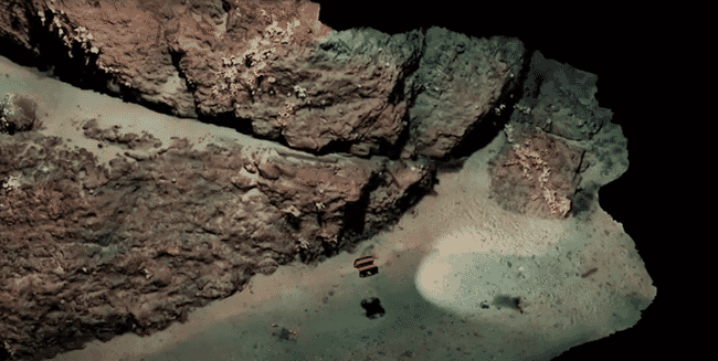
Over the next 12 months, the team at Tritonia, building on existing environmental data sets, will develop a digital record of the hard substrate found near selected Mowi sites, using a technique known as georeferenced photogrammetry. Compared to soft seabed, where samples of sediment can be taken regularly and easily, monitoring hard substrates can be challenging because of the low visibility of the water even when using divers or drop-down cameras to assess the terrain. The hard nature of the seabed makes it near impossible to grab samples.
The new system will use underwater ROVs linked to above water GPS technology and acoustic transponders to capture digital images of the seabed to assess current and future finfish farms, as well as identifying the presence of priority marine features – nationally protected habitats and essential underwater ecosystems. Using the images, Tritonia aims to create accurate 3D models that can show various physical characteristics and be used alongside advanced comparison software to monitor changes on the seabed.
Tritonia currently employs 3D photogrammetry to survey and monitor marine renewable installations, piers and harbours, and to inform decommissioning programmes in the oil and gas sector, but this project represents the company’s first breakthrough into aquaculture. The technology could present significant opportunities for companies in the sector to obtain accurate, digital records of the seabed below and close to their operations.
Martin Sayer, managing director of Tritonia Scientific, said: “Using imaging technology could help the aquaculture sector to gain a much more detailed, accurate picture of the complex seabeds they are operating beside or above. Our hope is that the system could ultimately support regulation and environmental monitoring in ways that would provide the levels of evidence that would be necessary for future sustainable operations.
“At the moment, divers face a range of challenges in terms of visibility and climate, particularly if algal blooms are present, but the digital twin allows us to essentially remove the surrounding water at the click of a button, using images captured by an ROV. Just one survey can generate a 3D model that provides a permanent record of the seabed terrain at a fixed point in time, which could be used for comparisons for years to come.”
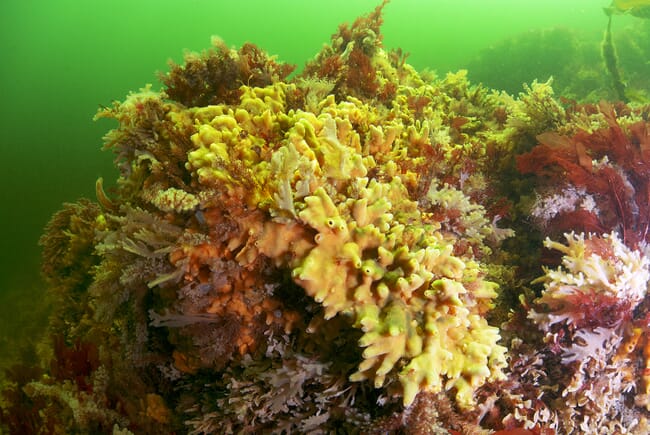
The technology could be used to detect protected habitats such as these, which are an important consideration for decisions about potential fish farm locations.
From a single ROV dive, a wealth of data and images can be captured to provide producers with accurate information to aid decision-making, such as the volume and area of specific geographical features. Information can also be used to detect protected habitats such as maerl beds - formed of red coralline algae – that, while difficult to map, are an important consideration for decisions about potential fish farm locations.
Heather Jones, CEO of SAIC, said in a press release: “Technology is becoming increasingly important for the aquaculture sector and collaborative research projects and trials can be an incredibly valuable demonstration of the real-world applications of new data-led techniques. In this case, we could see ROVs and imaging technology playing a vital role in monitoring the sector’s environmental impact and increasing its economic impact by supporting future decisions about farm locations and possible expansion.”
Dr Heidi Burdett, associate professor at the Lyell Centre, added: “Monitoring the effect of coastal industry and human activity on these habitats is crucial for understanding how best to protect them, but it remains logistically difficult. This project will allow us to overcome this using a scalable and flexible approach that brings the seabed into a virtual laboratory.”


