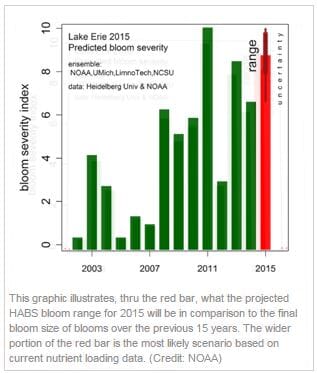
The US' National Oceanic and Atmospheric Administration (NOAA) and its research partners used an ensemble modelling approach to show that the event could become the second most severe behind the record-setting 2011 bloom.
The effects of the cyanobacterial blooms include a higher cost for cities and local governments to treat their drinking water, as well as risk to swimmers in high concentration areas, and a nuisance to boaters when blooms form. These effects will vary in locations and severity with winds, and will peak in September.
The bloom will be expected to measure 8.7 on the severity index with a range from 8.1 to potentially as high as 9.5. This is more severe than the last year’s 6.5, and may equal or exceed 2013, which had the second worse bloom in this century.
The severity index runs from a high of 10, which corresponds to the 2011 bloom, the worst ever observed, to zero. A severity above 5.0 indicates blooms of particular concern.
“While we are forecasting a severe bloom, much of the lake will be fine most of the time. The bloom will develop from west to east in the Lake Erie Western Basin, beginning this month. It is important to note that these effects will vary with winds, and will peak in September,” said Richard Stumpf, PhD, NOAA’s ecological forecasting applied research lead at NCCOS, who formally presented the forecast in a media event and science presentation at Ohio State University’s Stone Lab on Lake Erie today.
“This is the fourth seasonal harmful algal bloom outlook for Lake Erie that NOAA has issued,” said Holly Bamford, PhD, assistant NOAA administrator for the National Ocean Service performing duties of the assistant secretary of commerce for conservation and management.
“NOAA’s ecological forecasting initiative, including this Lake Erie seasonal forecast, the NOAA weekly HAB bulletin, and the experimental early season HABs Tracker, provide science-based information that water managers, public health officials, and others need to make critical decisions to protect the health of their communities, understand environmental impacts, and mitigate damages to recreational activities that are a vital part of the region’s economy.”
The 2015 seasonal forecast uses models that translate spring nutrient loading into predicted algal blooms in the western basin of Lake Erie.
After a relatively dry April and May, the heavy rains in June produced record discharge and nutrient loadings from the Maumee River, which runs through Toledo, Ohio as well as northeastern Indiana, will result in a more severe bloom. This marks the fourth year that NOAA has issued an annual outlook for western Lake Erie.
Models were developed by scientists at NOAA’s National Centers for Coastal Ocean Science (NCCOS), the University of Michigan, LimnoTech, the University of Michigan Cooperative Institute for Limnology and Ecosystems Research, and the NOAA Great Lakes Environmental Research Laboratory (GLERL). The models use nutrient load data collected by Heidelberg University’s National Center for Water Quality Research.
“Last summer’s Toledo water crisis was a wake-up call to the serious nature of harmful algal blooms in America’s waters,” said Jeff Reutter, PhD, senior advisor to, and former director of, The Ohio State University’s Sea Grant program and Stone Laboratory.
“This forecast once again focuses attention on this issue, and the urgent need to take action to address the problems caused by excessive amounts of nutrients from fertiliser, manure and sewage flowing into our lakes and streams.”
To provide more real-time information during the bloom season, NOAA has produced HAB bulletins for western Lake Erie since 2008. The bulletins will continue at the twice-weekly frequency established during last season’s Toledo event, and can be received by a subscription to the NOAA Lake Erie HAB Bulletin.
Additional information on the size and movement of the bloom can be found via NOAA’s experimental HAB Tracker. As the summer progresses, field observations on water quality, algal biomass and toxicity will be collected by NOAA GLERL and CILER, the Ohio State University’s Sea Grant Program and Stone Laboratory, Heidelberg University, the University of Toledo, Ohio EPA, and LimnoTech.
USGS will work with NASA in providing satellite tracking of the bloom as well. These results will provide valuable information to regional managers and assist NCCOS scientists in further refining the accuracy of this year’s forecast models.
NOAA, NASA, EPA, and the U.S. Geological Survey announced, in April, a $3.6 million multi-agency research effort designed to be an early warning system for freshwater nuisance and toxic algal blooms by using satellites that can gather color data from freshwater bodies during scans of the Earth.
The project will improve the understanding of the environmental causes and health effects of cyanobacteria and phytoplankton blooms. The effort includes the Great Lakes and will further strengthen initiatives like the NOAA Lake Erie HABs forecast.


