In our previous article on The Fish Site, we discussed controlled intensification: the reduction of aquaculture farm area to make room for natural habitat, while increasing crop output through intensive production methods. Controlled intensification is a concept that has gained momentum and is supported by leading NGOs. The major rationale for controlled intensification is that pond aquaculture consumes significant amounts of natural habitat.
Today, for example, low productivity shrimp farms (extensive systems) consume a third of all land used by shrimp farming (farm area and land required for feed ingredients) yet contribute just 11 percent of production by volume. Controlled intensification, however, requires a significant amount of energy to operate pumps and aerators, and is often derived from non-renewable sources. Therefore 50 percent of carbon emissions are attributed to on-farm energy for intensive systems.
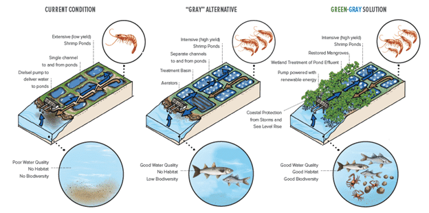
Figure 1. Controlled intensification (right) balances intensive production with restored natural habitat and renewable energy systems. Click on image to enlarge. © Conservation International
A possible solution
Satellite intelligence intended for aquaculture mapping and monitoring can also identify potential opportunity sites for solar and mangrove habitat in existing aquaculture production areas, and can also track progress of projects underway. While we do not claim to be renewable energy or mangrove experts, satellite intelligence could be employed by supporters of controlled intensification to identify sites for further assessment.
Step 1: aquaculture detection and mapping
Using satellite imagery and a deep learning object detection algorithm, we detect 292 aquaculture ponds, covering 134 hectares in a 16 km2 shrimp farming area in southern Thailand (Figure 2). We automatically measure the size, dimensions, and location of each pond for later use. Additional features, such as the number of aeration devices, help us to classify production intensity.
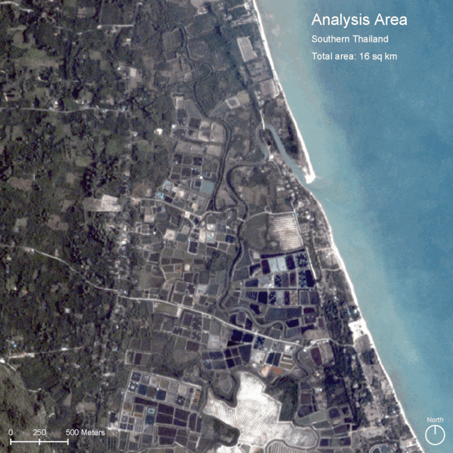
© SeaWarden*
Step 2: estimation of solar power and mangrove habitat potential
Based on pond size and local solar energy availability (dependent on latitude and number of sunny days per year) we estimate the amount of energy that could be generated using photovoltaic panels (Figure 3). Using moderate assumptions on equipment efficiency, we estimate around 1.13 gigawatt hours annually per hectare could be generated in this area.
Restoring mangrove habitat is challenging, with success strongly linked with proper hydrologic conditions and land ownership. For this reason, ponds with regular water exchange from natural tidal fluctuations would likely be the most attractive sites. For estimation purposes, every hectare of mangrove habitat has the potential to sequester around 6–8 tonnes of carbon annually.
© SeaWarden
Step 3: selection of solar and mangrove habitat opportunity sites
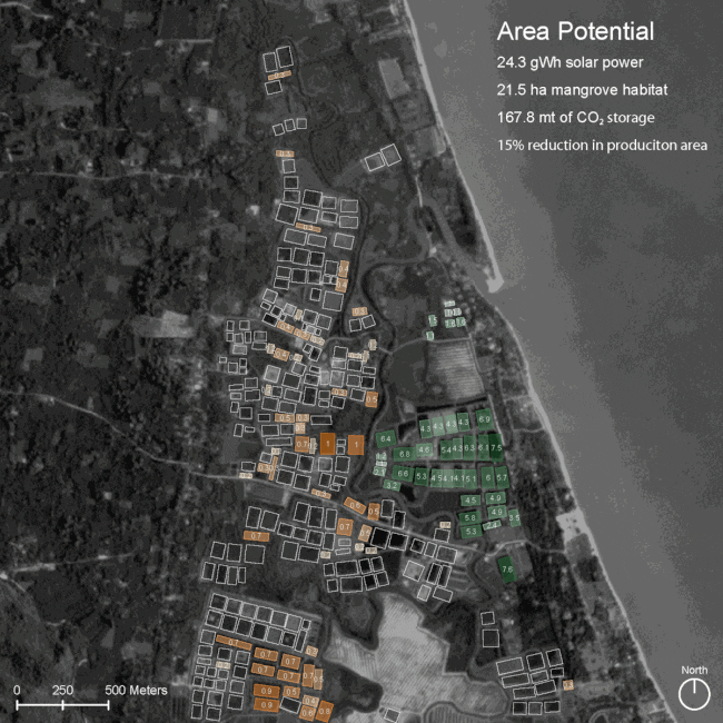
We analysed hundreds of satellite images between 2019 and 2021 to determine pond productivity in the area. Historic imagery, in conjunction with pond shape and aeration, help us distinguish between ponds used for production and those used for water treatment or storage. Since high productivity shrimp farms produce 2–3 crops a year, ponds with consistently poor productivity (1 crop a year maximum) could be considered candidates for decommissioning (Figure 4).
In this scenario, a third of the pond surface in this area (42 hectares) was identified as a potential solar or mangrove opportunity site, while only reducing the aquaculture production area by 15 percent. This could be achieved by:
Decommissioning a cluster of low productivity ponds nearest to the coast, yielding 21 hectares of mangrove habitat that could annually sequester 168 tonnes of CO2.
Placing solar panels within the non-production ponds of active farms using stilts or floats, could yield 21 hectares of solar, while enabling these ponds to retain their water treatment and storage functionality.
24.3 gigawatt hours of electricity could be generated annually – more than enough to power the farming activity in this area (based on 0.139 gigawatt hours needed annually per hectare of intensive shrimp production).
Figure 4: pond productivity based on historic satellite imagery was used to identify non-production and low-productivity ponds that could be opportunity sites for solar and mangrove habitat. © SeaWarden
Who should embrace this approach?
NGOs have been the strongest supporters of controlled intensification while also having a great track record of championing large-scale mapping initiatives (eg Global Mangrove Watch, Global Solar Atlas, Global Fishing Watch). An NGO-led effort would provide a powerful resource useful for government management agencies and industry.
Large commercial producers/processors: can also leverage satellite intelligence to help achieve environmental, social, and governance (ESG) targets. Producers using satellite intelligence to reduce supply chain risk, generate traceability data, and to forecast crop yields, can additionally use satellite intelligence to assess how each farm in their portfolio can contribute to carbon reduction, clean energy and habitat creation targets.
*SeaWarden is part of Hatch's investment portfolio, but The Fish Site retains editorial independence.


