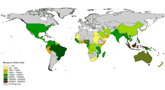
Most are found within latitude 25° north and south of equator, covering approximately 17 million ha (Aizpuru et al, 2000) in 112 countries and territories in Asia, Africa, Australia, and the Americas.
Global estimates of mangrove coverage vary considerably, for example, according to FAO there were 15.2 million ha as at 2005 (FAO, 2007). Close to half of mangrove coverage occurs in five countries, i.e. Indonesia, Australia, Brazil, Nigeria and Mexico. Mangroves are unique as they occupy an ecotone between land and sea, where the environment is distinctly different from marine and terrestrial environs.
Global extent of mangroves (FAO 2004)
At present, south east Asia harbours the largest extent of mangroves on Earth, i.e. 4.9 million ha or nearly 35 per cent of the world’s total, with coverage along the coasts of Brunei Darussalam (0.3 per cent of total south east Asian area), Cambodia (1.3 per cent), Indonesia (59.8 per cent), Malaysia (11.7 per cent), Myanmar (8.8 per cent), Papua New Guinea (8.7 per cent), Philippines (2.2 per cent), Singapore (0.01 per cent), Thailand (5.0 per cent), Timor-Leste (0.03 per cent), and Vietnam (2.1 per cent) (Giesen et al, 2006).
The largest mangrove areas in south east Asia therefore occur in Indonesia. In general, the mangroves of south east Asia are the best developed and most diverse in terms of plants and animals. Fifty two out of the 268 plant species that have been recorded from these mangrove areas are true mangrove species or those that are found only in mangrove habitats while the others are mangrove associated species that are also encountered in non-mangrove habitats. Eighteen species of mangrove plants are endemic to the south east Asian region and eight out of them are true mangroves (Giesen & Wulffraat, 1998).
Mangrove habitat
Inter-tidal areas with accumulated river-borne sediment due to the sheltered nature of the locality from wave action are the ideal habitats to be colonised by mangrove plants. Although it was believed initially that mangroves trap sediment, the current consensus is that mangroves consolidate the sediment that has been deposited through flocculation (Chapman, 1977).
Tidal action is a primary factor that determines mangrove ecology, i.e. ecosystem processes. Mangrove habitats are inundated with tides, either daily or a few days a month (spring tides) and thus the sediment is saline. Greater soil salinities occur in dry coastal areas where rainfall is insufficient to flush off salt from soil periodically. Inundation leads to anaerobic soil environments where oxygen is scarce for plant root systems. The soils are unstable due to tidal movement of water and therefore are unfavourable to support plants. Freshwater is a scare resource in mangrove habitats and hence conditions are not conducive for seed germination.
Extent and distribution of mangroves in study areas of MANGROVE project
The MANGROVE project aims to develop strategies to reconcile multiple demands on mangrove resources. The project is focussing on areas of Mahakam delta in East Kalimantan, Indonesia; the Province of Nakhon Si Thammarat in southern Thailand; and Tien Hai district of Thai Binh Province in Red River Delta in Vietnam. These sites have been selected as representative areas characterised by conflicting interests in terms of management, governance and use of mangrove resources that have led to significant decline in mangrove extents.
Indonesia
Indonesian mangroves comprise nearly 22 per cent of the global total or 60 per cent of the mangroves in south east Asia, with some 3.5 million ha distributed along sheltered coasts of Sumatra (over 570,000 ha), Kalimanthan (1,139,460 ha), Java (33,800 ha), Sulawesi (about 256,800 ha), Lesser Sundas (15,400 ha), Moluccas (148,710 ha) and Iriyan Jaya (1,326,990 ha) (Wilkie and Fortuna, 2003).
In Kalimantan, which harbours 32.6 per cent of all Indonesian mangroves, the least disturbed areas are mostly restricted to West Kalimantan where 15,000 ha are protected in Gunung Palung National Park, Muara Kendawangan Wildlife Reserve and Tanjung Puting National Park. (Giesen et al, 2006). The largest mangrove area in East Kalimantan occurs in the delta of Mahakam River, which is the study site of MANGROVE project in Indonesia. These mangroves have either been logged or disturbed by other land uses such as drilling for oil and gas, shrimp farming, development of ports and human settlements. (Refer Situation of the mangrove ecosystem and the related community livelihoods in Muara Badak, Mahakam Delta, East Kalimantan, Indonesia).
Thailand
The total extent of mangrove areas in Thailand also lacks consensus. According to Wilkie and Fortuna, 2003, from 1973 to 2000 mangroves of Thailand have dwindled from 312,732 to 244,085 ha while Charupat and Charupat (1997) recorded a decline from 372,448 ha in 1961 to 167,582 ha in 1996. The Department of Marine and Coastal Resource (DMCR), estimates the total extent of mangroves in Thailand to be 233,700 ha in 2004. (Refer Multidisciplinary situation appraisal of mangrove ecosystems in Thailand.
Mangroves are distributed on the coasts of Indian Ocean and Gulf of Thailand. The largest remaining mangrove areas occur on the coastal areas of the Indian Ocean and they are found in Phang Nga (45,500 ha), Satun (35,300 ha), Krabi (35,000 ha), Trang (33,500 ha) and Ranong (25,300 ha) provinces (Giesen et al, 2006).
Being an estuarine complex with a sheltered coast to which four major rivers, the Mae Klong, Tachin, Chao Phraya and Bang Pakong discharge freshwater, the Gulf of Thailand is the ideal habitat for mangroves. In the past, it has supported extensive areas of mangroves which have subsequently been cleared for aquaculture, salt pans and human settlements. Currently, mangroves of Gulf of Thailand are restricted to a narrow (10 – 100 m) fringe along the coast (Giesen et al, 2006). The study site of MANGROVE Project in Thailand is in the Province of Nakhon Si Thammarat, which borders Gulf of Thailand.
The coast of Andaman sea (Indian Ocean) supports 75 per cent of mangroves in Thailand which accounts for 174,335 ha while the extent around Gulf of Thailand is relatively low, covering only 59,365 ha (DMCR unpublished records). The southern part of Gulf of Thailand harbours 12 per cent of the remaining mangroves in Gulf of Thailand and only 4.4 per cent or 10,278 ha are located in Nakhon Si Thammarat.
Vietnam
The largest extent of mangroves occurs in southern Vietnam associated with Dong Nai and the Mekong River estuaries, with over 191,800 ha while the second largest extent, i.e. 39,400 ha lies in the north eastern Quang Ninh Province followed by those in the estuaries of Thai Binh and Hong (Red) rivers, 7,000 ha in the northern part of Vietnam. The coastal areas in central part of Vietnam supports the least (3,000 ha) extent of mangroves (Giesen et al, 2006). The total extent of mangroves has been estimated to be 252,500 ha in 1983 (FAO, 2004).
Xuan Thuy Wetland Reserve in Red river delta is the study site of MANGROVE project and it has been declared as a RAMSAR site in 1988. This is the largest remaining mangrove area in the Red River Delta.
Changing mangrove extent and causes
Available data on changing global extents of mangroves also manifest a lack of consensus, although they do indicate common trajectories of change.
During the past 25 years, 3.6 million hectares of mangroves or approximately 20 per cent of the total extent found in 1980, have disappeared from the Earth’s surface. Conservative estimates indicate that on a global scale, mangroves decline by 1,000 km2 annually. The rate of net loss of mangroves however show a decreasing propensity, from 1.03 per cent loss per annum in 1980 to 0.67 per cent annual loss during 2000–2005 period. This is attributed to increased awareness of the value of mangrove ecosystems, which has led, in turn, to the preparation of new legislation, better protection and management and, in some countries, to an expansion of mangrove areas through active planting or natural regeneration (FAO, 2007).
Results of a trend analysis published in the Forest Resources assessment Working Paper-063 (of FAO (2004)) indicate that the current mangrove area worldwide has now fallen below 15 million hectares, down from 19.8 million ha in 1980. The world has thus lost 5 million ha of mangroves over the last twenty years, or 25 percent of the extent found in 1980.
Indonesia
Shrimp farming evidently is the cause of approximately 25 per cent loss of mangroves in Indonesia while conversion to agricultural, mainly paddy land, over-exploitation by coastal communities, commercial logging and lack of effort on regeneration of degraded and over-exploited mangrove areas have been identified the reasons for 75 per cent of the mangrove loss (Giesen et al, 2006).
Commercial logging that has taken place in Sumatra, and Kalimantan Provinces is currently been extended to Iriyan Jaya in Papua. Transmigration programme that facilitated human migration from over-populated Java to Kalimantan and Papua also had made an impact on tidal wetland extent (including mangroves) as they have been reclaimed for human settlements and urban expansion to accommodate the migrants.
Thailand
Charuppat & Charuppat (1997) estimated that Thailand’s mangroves have declined 55 per cent of its extent prior to 1961, within 35 yrs. Kongsanchai (1994) also estimates that about 50 per cent of mangrove areas in Thailand have been converted to other land uses before 1991. On contrary, a decrease only of 22 per cent from the mangrove extent in 1973 has been estimated by Wilkies and Fortuna (2003) for the period of 1973-2000 (27 years).
Available information on percentage mangrove loss due to clearing for shrimp pond construction too vary from 33 per cent (Charuppat & Charuppat, 1997) to 65 per cent (Wattayakorn (1998) cited by Giesen et al, 2006). Other causes for mangrove loss include coastal zone development, urban expansion, agriculture, resettlement, construction of harbours and ports, establishment of salt ponds and mining.
Due to re-plantation of mangroves in abandoned shrimp ponds by the Royal Forest Department, the total mangrove extent in Thailand has shown an increase during the past decade (Giesen et al, 2006).
Vietnam
The extensive mangrove areas (400,000 ha) along the sheltered coasts of Vietnam have been destroyed during the war and hence the extent was reduced to 104,123 ha by 1971. Use of the herbicide “agent orange”, artillery and bombardment destroyed 149,850 ha of mangrove forests in the Mekong delta in southern Vietnam (Hong, 2003). In later years mangroves have also been felled for shrimp and fish aquaculture.
Mangrove re-plantation programmes had successfully re-vegetated 96,876 ha of the 155, 290 ha of degraded and destroyed mangrove areas by 1999 (Hong, 2003). Professor Phan Nguyen Hong from the National University of Education in Vietnam who played an active role in the initial phase of the MANGROVE project was awarded the International Cosmos Prize in 2008 for his contribution to rehabilitating mangrove areas of Vietnam.
March 2009


